
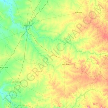
Moqhaka Ward 2 topographic map
Interactive map
Click on the map to display elevation.
About this map
Name: Moqhaka Ward 2 topographic map, elevation, terrain.
Average elevation: 1,470 m
Minimum elevation: 1,304 m
Maximum elevation: 1,838 m
Other topographic maps
Click on a map to view its topography, its elevation and its terrain.
Kroonstad
South Africa > Free State > Fezile Dabi District Municipality > Moqhaka Local Municipality
Kroonstad, Moqhaka Local Municipality, Fezile Dabi District Municipality, Free State, 1499, South Africa
Average elevation: 1,380 m
Viljoenskroon
South Africa > Free State > Fezile Dabi District Municipality > Moqhaka Local Municipality
Viljoenskroon, Moqhaka Local Municipality, Fezile Dabi District Municipality, Free State, South Africa
Average elevation: 1,335 m
Moqhaka Local Municipality
South Africa > Free State > Fezile Dabi District Municipality > Moqhaka Local Municipality
Moqhaka Local Municipality, Fezile Dabi District Municipality, Free State, South Africa
Average elevation: 1,410 m
Vierfontein
South Africa > Free State > Fezile Dabi District Municipality > Moqhaka Local Municipality
Vierfontein, Moqhaka Local Municipality, Fezile Dabi District Municipality, Free State, South Africa
Average elevation: 1,349 m
Steynsrus
South Africa > Free State > Fezile Dabi District Municipality > Moqhaka Local Municipality
Steynsrus, Moqhaka Local Municipality, Fezile Dabi District Municipality, Free State, 9515, South Africa
Average elevation: 1,520 m