
Thank you for supporting this site ❤️
Make a donation
Make a donation
Swartberg topographic map
Click on the map to display elevation.
Thank you for supporting this site ❤️
Make a donation
Make a donation
About this map
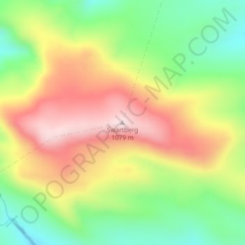
Name: Swartberg topographic map, elevation, terrain.
Average elevation: 852 m
Minimum elevation: 642 m
Maximum elevation: 1,085 m
Thank you for supporting this site ❤️
Make a donation
Make a donation
Other topographic maps
Click on a map to view its topography, its elevation and its terrain.
Theewaterskloof Dam
South Africa > Western Cape > Theewaterskloof Local Municipality
Average elevation: 434 m
Elandskloof Dam
South Africa > Western Cape > Theewaterskloof Local Municipality
Average elevation: 659 m