
Thank you for supporting this site ❤️
Make a donation
Make a donation
Haut-Clocher topographic map
Click on the map to display elevation.
Thank you for supporting this site ❤️
Make a donation
Make a donation
About this map
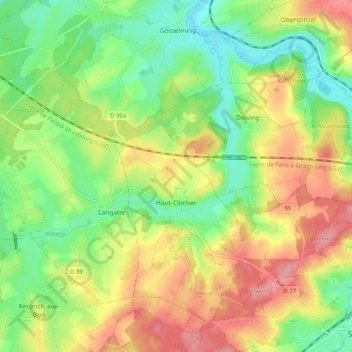
Name: Haut-Clocher topographic map, elevation, terrain.
Average elevation: 277 m
Minimum elevation: 233 m
Maximum elevation: 329 m
Thank you for supporting this site ❤️
Make a donation
Make a donation
Other topographic maps
Click on a map to view its topography, its elevation and its terrain.
Thank you for supporting this site ❤️
Make a donation
Make a donation
Malancourt-la-Montagne
Frankrijk > Grand Est > Moselle > Malancourt-la-Montagne
Average elevation: 326 m
Thank you for supporting this site ❤️
Make a donation
Make a donation