
Rough Tor topographic map
Interactive map
Click on the map to display elevation.
About this map
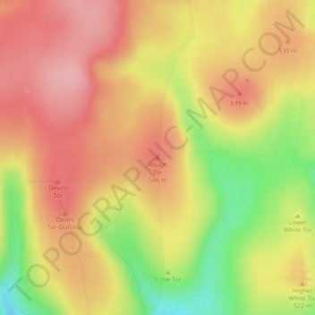
Name: Rough Tor topographic map, elevation, terrain.
Average elevation: 511 m
Minimum elevation: 427 m
Maximum elevation: 562 m
Other topographic maps
Click on a map to view its topography, its elevation and its terrain.
Sticklepath
Royaume-Uni > Angleterre > West Devon > Sticklepath
Sticklepath, West Devon, Devon, South West England, Angleterre, EX20 2NW, Royaume-Uni
Average elevation: 257 m
Chagford
Royaume-Uni > Angleterre > West Devon > Chagford
Chagford, West Devon, Devon, South West England, Angleterre, TQ13 8AA, Royaume-Uni
Average elevation: 254 m
Horrabridge
Royaume-Uni > Angleterre > West Devon > Horrabridge
Horrabridge, West Devon, Devon, South West England, Angleterre, PL20 7ST, Royaume-Uni
Average elevation: 157 m
Dartmoor
Royaume-Uni > Angleterre > West Devon
Dartmoor, B3357, Dartmoor Forest, West Devon, Devon, South West England, Angleterre, PL20 6SB, Royaume-Uni
Average elevation: 239 m