
Thank you for supporting this site ❤️
Make a donation
Make a donation
Salambigar topographic map
Click on the map to display elevation.
Thank you for supporting this site ❤️
Make a donation
Make a donation
About this map
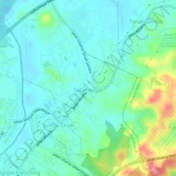
Name: Salambigar topographic map, elevation, terrain.
Location: Salambigar, Mukim Berakas B, Brunei-Muara District, Brunei (4.96441 114.97413 5.00036 115.00130)
Average elevation: 25 m
Minimum elevation: 0 m
Maximum elevation: 107 m
Thank you for supporting this site ❤️
Make a donation
Make a donation
Other topographic maps
Click on a map to view its topography, its elevation and its terrain.