
Thank you for supporting this site ❤️
Make a donation
Make a donation
Coria topographic map
Click on the map to display elevation.
Thank you for supporting this site ❤️
Make a donation
Make a donation
About this map
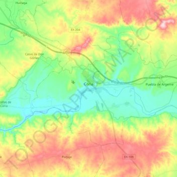
Name: Coria topographic map, elevation, terrain.
Location: Coria, Cáceres, Extremadura, 10800, Spanje (39.92805 -6.60423 40.02967 -6.39768)
Average elevation: 306 m
Minimum elevation: 212 m
Maximum elevation: 444 m
Thank you for supporting this site ❤️
Make a donation
Make a donation
Other topographic maps
Click on a map to view its topography, its elevation and its terrain.
San Benito de la Contienda
Spanje > Extremadura > Llanos de Olivenza > Olivenza
Average elevation: 227 m
Thank you for supporting this site ❤️
Make a donation
Make a donation
Mirador sobre el valle de la Cervigona
Spanje > Extremadura > Sierra de Gata > Acebo
Average elevation: 1,130 m