
Hambourg topographic map
Interactive map
Click on the map to display elevation.
About this map
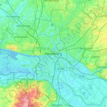
Name: Hambourg topographic map, elevation, terrain.
Location: Hambourg, 20095, Allemagne (53.39034 9.84065 53.71034 10.16065)
Average elevation: 23 m
Minimum elevation: -3 m
Maximum elevation: 150 m
Hambourg se trouve à une latitude de 53°33'2" Nord, longitude de 9°59'36" Est, à l'altitude de 6 m.
Other topographic maps
Click on a map to view its topography, its elevation and its terrain.
Fuhlsbüttel
Allemagne > Hambourg > Hambourg
Fuhlsbüttel, Hamburg-Nord, Hambourg, Allemagne
Average elevation: 19 m
Binnenalster
Allemagne > Hambourg > Hambourg
Binnenalster, Ballindamm, Hamburg-Altstadt, Hamburg-Mitte, Hambourg, 20095, Allemagne
Average elevation: 13 m
Bahrenfeld
Allemagne > Hambourg > Hambourg
Bahrenfeld, Altona, Hambourg, 22761, Allemagne
Average elevation: 29 m