
La Cruz topographic map
Interactive map
Click on the map to display elevation.
About this map
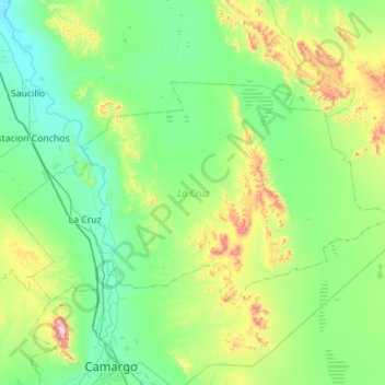
Name: La Cruz topographic map, elevation, terrain.
Location: La Cruz, Chihuahua, Mexique (27.75763 -105.31647 28.04331 -104.75792)
Average elevation: 1,333 m
Minimum elevation: 1,163 m
Maximum elevation: 1,974 m
Other topographic maps
Click on a map to view its topography, its elevation and its terrain.
Los Hornitos
Mexique > Chihuahua > Los Hornitos
Los Hornitos, Riva Palacio, Chihuahua, Mexique
Average elevation: 1,828 m