
Solon topographic map
Interactive map
Click on the map to display elevation.
About this map
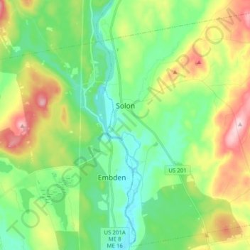
Name: Solon topographic map, elevation, terrain.
Location: Solon, Somerset County, Maine, 04979, United States (44.88718 -69.87442 44.99455 -69.72011)
Average elevation: 149 m
Minimum elevation: 74 m
Maximum elevation: 296 m
Other topographic maps
Click on a map to view its topography, its elevation and its terrain.
Moose River
United States > Maine > Somerset County
Moose River, Somerset County, Maine, United States
Average elevation: 473 m