
Thank you for supporting this site ❤️
Make a donation
Make a donation
Rauhberg topographic map
Click on the map to display elevation.
Thank you for supporting this site ❤️
Make a donation
Make a donation
About this map
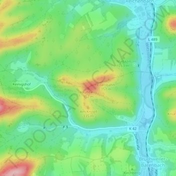
Name: Rauhberg topographic map, elevation, terrain.
Average elevation: 253 m
Minimum elevation: 194 m
Maximum elevation: 373 m
Thank you for supporting this site ❤️
Make a donation
Make a donation
Other topographic maps
Click on a map to view its topography, its elevation and its terrain.
Bruchweiler Falkenfels
Deutschland > Rheinland-Pfalz > Südwestpfalz > Bruchweiler-Bärenbach > Reinigshof
Average elevation: 262 m