
Graniteville topographic map
Interactive map
Click on the map to display elevation.
About this map
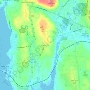
Name: Graniteville topographic map, elevation, terrain.
Average elevation: 22 m
Minimum elevation: -5 m
Maximum elevation: 77 m
Other topographic maps
Click on a map to view its topography, its elevation and its terrain.
Sandy Point
United States > Connecticut > Southeastern Connecticut Planning Region > Waterford
Sandy Point, Waterford, Southeastern Connecticut Planning Region, Connecticut, 06357, United States
Average elevation: 26 m
Central Waterford CDP
United States > Connecticut > Southeastern Connecticut Planning Region > Waterford
Central Waterford CDP, Waterford, Southeastern Connecticut Planning Region, Connecticut, 06385, United States
Average elevation: 22 m