
Sasbachwalden topographic map
Interactive map
Click on the map to display elevation.
About this map
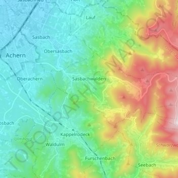
Name: Sasbachwalden topographic map, elevation, terrain.
Average elevation: 382 m
Minimum elevation: 133 m
Maximum elevation: 1,036 m
Other topographic maps
Click on a map to view its topography, its elevation and its terrain.
Hornisgrinde
Allemagne > Bade-Wurtemberg > Sasbachwalden
Hornisgrinde, Sasbachwalden, Verwaltungsgemeinschaft Achern, Ortenaukreis, Regierungsbezirk Freiburg, Bade-Wurtemberg, 77889, Allemagne
Average elevation: 968 m