
Touws River topographic map
Interactive map
Click on the map to display elevation.
About this map
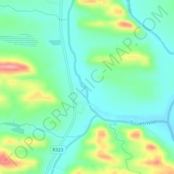
Name: Touws River topographic map, elevation, terrain.
Average elevation: 270 m
Minimum elevation: 234 m
Maximum elevation: 356 m
Other topographic maps
Click on a map to view its topography, its elevation and its terrain.
Buffelskloof
South Africa > Western Cape > Kannaland Local Municipality
Buffelskloof, Kannaland Local Municipality, Garden Route District Municipality, Western Cape, South Africa
Average elevation: 902 m
Brak River
South Africa > Western Cape > Kannaland Local Municipality
Brak River, Kannaland Local Municipality, Garden Route District Municipality, Western Cape, South Africa
Average elevation: 565 m