
Make a donation
Shapleigh topographic map
Click on the map to display elevation.
Make a donation
Shapleigh
The town has three mountains over 1,000 feet (300 m): Fort Ridge, Abbott Mountain and an unnamed mountain (1,017 feet; 310 m) located a half mile northwest of Abbott Mountain. Fort Ridge, with its highest summit at 1,114 feet (340 m) above sea level, is the town's highest mountain. Abbott Mountain, which is often mistaken to be the highest point in town, rises to an elevation of 1,078 feet (329 m), making it the town's second highest point. Due to its local popularity as a hiking destination, high traffic from all terrain vehicles (ATV) and the resulting erosion from overuse, the actual elevation of Abbott Mountain's ground-down summit is estimated to be closer to 1,060 feet in elevation.
Make a donation
About this map
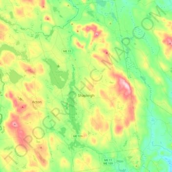
Name: Shapleigh topographic map, elevation, terrain.
Location: Shapleigh, York County, Maine, 04076, United States (43.47024 -70.90851 43.62767 -70.78031)
Average elevation: 177 m
Minimum elevation: 78 m
Maximum elevation: 337 m
Make a donation
Other topographic maps
Click on a map to view its topography, its elevation and its terrain.
Make a donation
Make a donation