
Thank you for supporting this site ❤️
Make a donation
Make a donation
滬尾 topographic map
Click on the map to display elevation.
Thank you for supporting this site ❤️
Make a donation
Make a donation
About this map
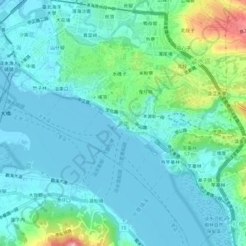
Name: 滬尾 topographic map, elevation, terrain.
Location: 滬尾, New Taipei, 25164, Taiwan (25.15105 121.41916 25.19105 121.45916)
Average elevation: 26 m
Minimum elevation: -3 m
Maximum elevation: 136 m
Thank you for supporting this site ❤️
Make a donation
Make a donation
Other topographic maps
Click on a map to view its topography, its elevation and its terrain.