
Thank you for supporting this site ❤️
Make a donation
Make a donation
Kensington topographic map
Click on the map to display elevation.
Thank you for supporting this site ❤️
Make a donation
Make a donation
About this map
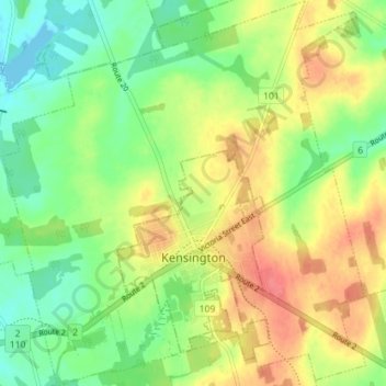
Name: Kensington topographic map, elevation, terrain.
Location: Kensington, Prince County, Prince Edward Island, Canada (46.41963 -63.67315 46.46876 -63.60604)
Average elevation: 29 m
Minimum elevation: -1 m
Maximum elevation: 64 m
Thank you for supporting this site ❤️
Make a donation
Make a donation
Other topographic maps
Click on a map to view its topography, its elevation and its terrain.