
Goukamma Nature Reserve topographic map
Interactive map
Click on the map to display elevation.
About this map
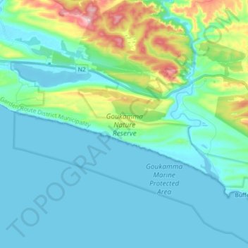
Name: Goukamma Nature Reserve topographic map, elevation, terrain.
Average elevation: 61 m
Minimum elevation: -1 m
Maximum elevation: 335 m
Other topographic maps
Click on a map to view its topography, its elevation and its terrain.
Knysna River
RSA > Western Cape > Knysna Local Municipality
Knysna River, Knysna Local Municipality, Garden Route District Municipality, Western Cape, 6571, RSA
Average elevation: 72 m
Karatararivier
RSA > Western Cape > Knysna Local Municipality
Karatararivier, Knysna Local Municipality, Garden Route District Municipality, Western Cape, 6573, RSA
Average elevation: 245 m