
Thank you for supporting this site ❤️
Make a donation
Make a donation
Buryatia topographic map
Click on the map to display elevation.
Thank you for supporting this site ❤️
Make a donation
Make a donation
About this map
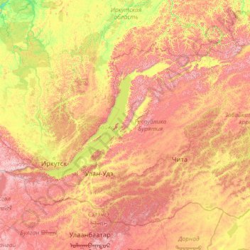
Name: Buryatia topographic map, elevation, terrain.
Location: Buryatia, Far Eastern Federal District, Russia (49.96978 98.62992 57.24988 116.92173)
Average elevation: 923 m
Minimum elevation: 160 m
Maximum elevation: 3,152 m
Thank you for supporting this site ❤️
Make a donation
Make a donation
Other topographic maps
Click on a map to view its topography, its elevation and its terrain.
Thank you for supporting this site ❤️
Make a donation
Make a donation
Thank you for supporting this site ❤️
Make a donation
Make a donation
Thank you for supporting this site ❤️
Make a donation
Make a donation
Thank you for supporting this site ❤️
Make a donation
Make a donation
Novoromanovka
Russia > Republic of Dagestan > Tarumovsky District > Novoromanovka
Average elevation: -8 m
Thank you for supporting this site ❤️
Make a donation
Make a donation
Thank you for supporting this site ❤️
Make a donation
Make a donation