
Lebrija topographic map
Interactive map
Click on the map to display elevation.
About this map
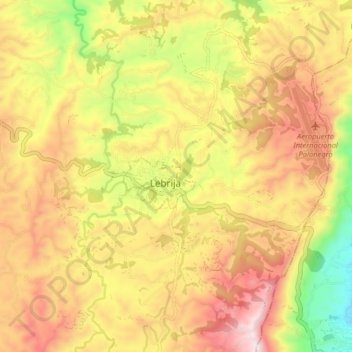
Name: Lebrija topographic map, elevation, terrain.
Location: Lebrija, Santander, Colombia (7.07508 -73.25490 7.15508 -73.17490)
Average elevation: 1,071 m
Minimum elevation: 683 m
Maximum elevation: 1,398 m
Other topographic maps
Click on a map to view its topography, its elevation and its terrain.
Cabecera Municipal Lebrija
Colombia > Santander > Lebrija
Cabecera Municipal Lebrija, Lebrija, Metropolitana, Santander, RAP Gran Santander, Colombia
Average elevation: 1,051 m