
Thank you for supporting this site ❤️
Make a donation
Make a donation
Saint-Lazare topographic map
Click on the map to display elevation.
Thank you for supporting this site ❤️
Make a donation
Make a donation
About this map
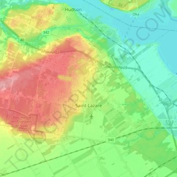
Name: Saint-Lazare topographic map, elevation, terrain.
Average elevation: 57 m
Minimum elevation: 17 m
Maximum elevation: 124 m
Thank you for supporting this site ❤️
Make a donation
Make a donation
Other topographic maps
Click on a map to view its topography, its elevation and its terrain.
Saint-Lazare
Canada > Quebec > Vaudreuil-Soulanges > Saint-Lazare > Saint-Lazare
Average elevation: 64 m
Domaine du Lac
Canada > Quebec > Vaudreuil-Soulanges > Notre-Dame-de-l'Île-Perrot
Average elevation: 27 m