
Halmaal topographic map
Interactive map
Click on the map to display elevation.
About this map
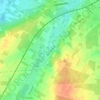
Name: Halmaal topographic map, elevation, terrain.
Location: Halmaal, Sint-Truiden, Hasselt, Limburg, Vlaanderen, België (50.79198 5.13271 50.80946 5.16016)
Average elevation: 61 m
Minimum elevation: 40 m
Maximum elevation: 83 m
Other topographic maps
Click on a map to view its topography, its elevation and its terrain.
Duras
België > Vlaanderen > Sint-Truiden > Duras
Duras, Sint-Truiden, Limburg, Vlaanderen, 3803, België
Average elevation: 39 m
Herk
België > Vlaanderen > Sint-Truiden
Herk, Sint-Truiden, Hasselt, Limburg, Vlaanderen, 3870, België
Average elevation: 83 m