
Košice topographic map
Interactive map
Click on the map to display elevation.
About this map
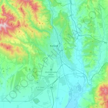
Name: Košice topographic map, elevation, terrain.
Location: Košice, Region of Košice, Eastern Slovakia, Slovakia (48.57004 21.11996 48.82451 21.35821)
Average elevation: 314 m
Minimum elevation: 166 m
Maximum elevation: 960 m
Košice lies at an altitude of 206 metres (676 ft) above sea level and covers an area of 242.77 square kilometres (93.7 sq mi). It is located in eastern Slovakia, about 20 kilometres (12 mi) from the Hungarian, 80 kilometres (50 mi) from the Ukrainian, and 90 kilometres (56 mi) from the Polish borders. It is about 400 kilometres (249 mi) east of Slovakia's capital Bratislava and a chain of villages connects it to Prešov which is about 36 kilometres (22 mi) to the north.
Other topographic maps
Click on a map to view its topography, its elevation and its terrain.
Bara
Slovakia > Region of Košice > District of Trebišov > Bara
Bara, District of Trebišov, Region of Košice, Eastern Slovakia, 076 32, Slovakia
Average elevation: 160 m
District of Košice I
Slovakia > Region of Košice > District of Košice I
District of Košice I, Košice, Region of Košice, Eastern Slovakia, Slovakia
Average elevation: 390 m
XII.
Slovakia > Region of Košice > District of Košice IV
XII., Košice - mestská časť Juh, District of Košice IV, Košice, Region of Košice, Eastern Slovakia, 04001, Slovakia
Average elevation: 218 m
District of Košice IV
Slovakia > Region of Košice > District of Košice IV
District of Košice IV, Košice, Region of Košice, Eastern Slovakia, Slovakia
Average elevation: 223 m
Stredné Mesto
Slovakia > Region of Košice > District of Košice I
Stredné Mesto, Košice - mestská časť Staré Mesto, District of Košice I, Košice, Region of Košice, Eastern Slovakia, Slovakia
Average elevation: 217 m