
Glanerbeek topographic map
Interactive map
Click on the map to display elevation.
About this map
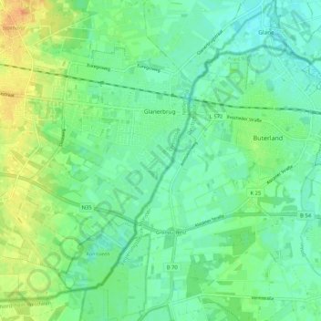
Name: Glanerbeek topographic map, elevation, terrain.
Location: Glanerbeek, Overijssel, Pays-Bas, 7534HC, Pays-Bas (52.17381 6.94102 52.23766 7.00738)
Average elevation: 44 m
Minimum elevation: 33 m
Maximum elevation: 64 m
Other topographic maps
Click on a map to view its topography, its elevation and its terrain.
Hellendoorn
Pays-Bas > Overijssel > Hellendoorn
Hellendoorn, Overijssel, Pays-Bas
Average elevation: 10 m
Sallandse Heuvelrug
Pays-Bas > Overijssel > Rijssen-Holten
Sallandse Heuvelrug, Plaggenweg, Holten, Rijssen-Holten, Overijssel, Pays-Bas, 7451RP, Pays-Bas
Average elevation: 35 m