
Chiayi County topographic map
Interactive map
Click on the map to display elevation.
About this map
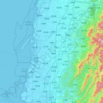
Name: Chiayi County topographic map, elevation, terrain.
Location: Chiayi County, Taiwan Province, Taiwan (23.21478 120.10658 23.63591 120.95760)
Average elevation: 137 m
Minimum elevation: -4 m
Maximum elevation: 1,875 m
Other topographic maps
Click on a map to view its topography, its elevation and its terrain.
Yuchi Township
Taiwan > Taiwan Province > Yuchi Township
Yuchi Township, Nantou County, Taiwan Province, Taiwan
Average elevation: 853 m
Zhudong
Taiwan > Taiwan Province > Zhudong
Zhudong, Hsinchu County, Taiwan Province, Taiwan
Average elevation: 257 m