
Thank you for supporting this site ❤️
Make a donation
Make a donation
Stella topographic map
Click on the map to display elevation.
Thank you for supporting this site ❤️
Make a donation
Make a donation
About this map
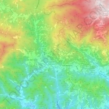
Name: Stella topographic map, elevation, terrain.
Location: Stella, Savona, Liguria, 17044, Italy (44.35842 8.44076 44.44075 8.56100)
Average elevation: 473 m
Minimum elevation: 36 m
Maximum elevation: 1,261 m
Thank you for supporting this site ❤️
Make a donation
Make a donation
Other topographic maps
Click on a map to view its topography, its elevation and its terrain.
Caverna delle Arene Candide
Italy > Liguria > Savona > Finale Ligure > Finalborgo
Average elevation: 69 m
Thank you for supporting this site ❤️
Make a donation
Make a donation
Thank you for supporting this site ❤️
Make a donation
Make a donation
Thank you for supporting this site ❤️
Make a donation
Make a donation
Thank you for supporting this site ❤️
Make a donation
Make a donation