
Make a donation
Menstrie topographic map
Click on the map to display elevation.
Make a donation
Menstrie
Menstrie stands on the carse or flood plain of the River Devon, between 10 and 20 metres altitude above sea level. It is roughly astride the Ochil Fault whose movement gave rise to the dramatic southern scarp of the Ochils but which is now almost quiescent.
Make a donation
About this map
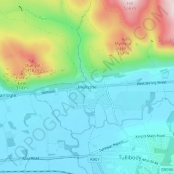
Name: Menstrie topographic map, elevation, terrain.
Location: Menstrie, Clackmannanshire, Scotland, FK11 7BL, United Kingdom (56.13142 -3.87377 56.17142 -3.83377)
Average elevation: 129 m
Minimum elevation: 3 m
Maximum elevation: 527 m
Make a donation
Other topographic maps
Click on a map to view its topography, its elevation and its terrain.
River Devon
United Kingdom > Scotland > Clackmannanshire > Tillicoultry
The source of the river is Blairdenon Hill in the Ochils at an altitude of 1,800 feet (550 m). Upper areas have been dammed, creating Upper Glendevon, Lower Glendevon and Castlehill reservoirs. The Devon then flows east and southeast through Glendevon, turning southwest at Crook of Devon and then continuing…
Average elevation: 96 m
Make a donation