
Thank you for supporting this site ❤️
Make a donation
Make a donation
Enterprise topographic map
Click on the map to display elevation.
Thank you for supporting this site ❤️
Make a donation
Make a donation
About this map
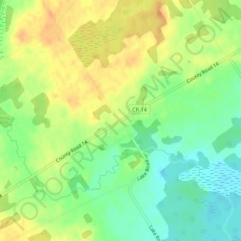
Name: Enterprise topographic map, elevation, terrain.
Average elevation: 153 m
Minimum elevation: 135 m
Maximum elevation: 168 m
Thank you for supporting this site ❤️
Make a donation
Make a donation
Other topographic maps
Click on a map to view its topography, its elevation and its terrain.
Lions Beaver Lake Park
Canada > Ontario > Lennox and Addington County > Stone Mills > Erinsville
Average elevation: 172 m
Puzzle Lake Provincial Park
Canada > Ontario > Lennox and Addington County > Stone Mills
Average elevation: 196 m
Thank you for supporting this site ❤️
Make a donation
Make a donation