
Thank you for supporting this site ❤️
Make a donation
Make a donation
Lissendorf topographic map
Click on the map to display elevation.
Thank you for supporting this site ❤️
Make a donation
Make a donation
About this map
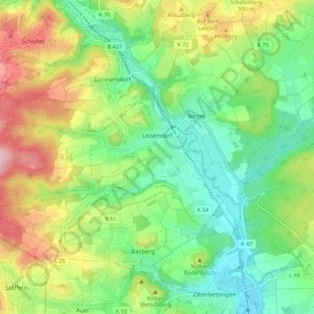
Name: Lissendorf topographic map, elevation, terrain.
Average elevation: 470 m
Minimum elevation: 389 m
Maximum elevation: 607 m
Thank you for supporting this site ❤️
Make a donation
Make a donation
Other topographic maps
Click on a map to view its topography, its elevation and its terrain.
Wirfttal bei Stadtkyll
Duitsland > Rijnland-Palts > Landkreis Vulkaneifel > Stadtkyll
Average elevation: 543 m
Vulkanfeld Westeifel
Duitsland > Rijnland-Palts > Landkreis Vulkaneifel > Schalkenmehren
Average elevation: 467 m
Thank you for supporting this site ❤️
Make a donation
Make a donation
Niedereich
Duitsland > Rijnland-Palts > Landkreis Vulkaneifel > Gerolstein > Büscheich > Niedereich
Average elevation: 478 m