
Thank you for supporting this site ❤️
Make a donation
Make a donation
Hazlerigg topographic map
Click on the map to display elevation.
Thank you for supporting this site ❤️
Make a donation
Make a donation
About this map
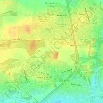
Name: Hazlerigg topographic map, elevation, terrain.
Average elevation: 66 m
Minimum elevation: 48 m
Maximum elevation: 78 m
Thank you for supporting this site ❤️
Make a donation
Make a donation
Other topographic maps
Click on a map to view its topography, its elevation and its terrain.
Middle Brunton
United Kingdom > England > Newcastle upon Tyne > Hazlerigg Village
Average elevation: 63 m