
Djelfa topographic map
Interactive map
Click on the map to display elevation.
About this map
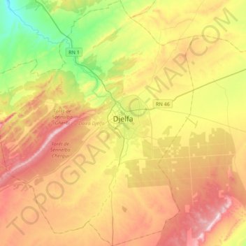
Name: Djelfa topographic map, elevation, terrain.
Location: Djelfa, Djelfa District, Djelfa, Algeria (34.52510 3.06894 34.80481 3.35258)
Average elevation: 1,194 m
Minimum elevation: 938 m
Maximum elevation: 1,482 m
Djelfa is located at an elevation of 3,734 feet (1,138 m) in the Ouled Naïl Range of north-central Algeria, between the towns of Bousaada and Laghouat. It is situated in a transitional zone between the dry, steppe-like Hautes Plaines (high plateaus) of the north, characterized by chotts (intermittent salt lakes), and the Sahara to the south. The town was founded in 1852 as a French military post on a geometric plan. It serves as an important livestock market centre for the semi-nomadic Ouled Naïl confederation. Djelfa is on the 12,000 mile-long Africa Trail.