Geolocate

Moriting topographic map

Interactive map

Click on the map to display elevation.

About this map

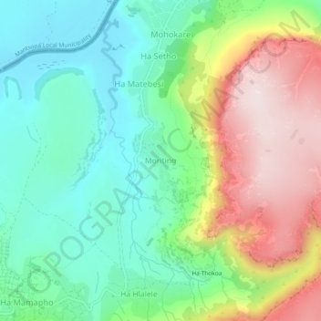
Name: Moriting topographic map, elevation, terrain.

Location: Moriting, Maseru District, Lesotho (-29.44469 27.41070 -29.40469 27.45070)

Average elevation: 1,649 m

Minimum elevation: 1,468 m

Maximum elevation: 1,958 m

Other topographic maps

Click on a map to view its topography, its elevation and its terrain.

Ha Motheo

Lesotho > Maseru District > Temaneng

Ha Motheo, Temaneng, Maseru District, Lesotho

Average elevation: 1,779 m

Mohlakeng

Lesotho > Maseru District > Moriting

Mohlakeng, Ha Matebesi, Moriting, Ha Tsiu, Maseru District, Lesotho

Average elevation: 1,543 m

Maseru

Lesotho > Maseru District

Maseru, Ha Tsiu, Maseru District, 100, Lesotho

Average elevation: 1,606 m

Thaba Bosiu

Lesotho > Maseru District > Thaba Bosiu

Thaba Bosiu, Maseru District, Lesotho

Average elevation: 1,625 m