
Thank you for supporting this site ❤️
Make a donation
Make a donation
Kontomari topographic map
Click on the map to display elevation.
Thank you for supporting this site ❤️
Make a donation
Make a donation
About this map
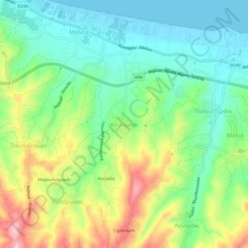
Name: Kontomari topographic map, elevation, terrain.
Average elevation: 68 m
Minimum elevation: -1 m
Maximum elevation: 191 m
Thank you for supporting this site ❤️
Make a donation
Make a donation
Other topographic maps
Click on a map to view its topography, its elevation and its terrain.
Gavdos
Griechenland > Region Kreta > Regionalbezirk Chania
Die Insel Gavdos liegt 34,9 km südlich von Kreta im Libyschen Meer und ist damit geografisch gesehen die südlichste Insel Europas. Zusammen mit ihrer unbewohnten kleineren Schwesterinsel Gavdopoula bildet sie die südlichste griechische Gemeinde. Die geringste Entfernung zur afrikanischen Nordküste beträgt…
Average elevation: 56 m