
Ohiwa topographic map
Interactive map
Click on the map to display elevation.
About this map
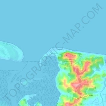
Name: Ohiwa topographic map, elevation, terrain.
Location: Ohiwa, Ōpōtiki District, Bay of Plenty, 3198, New Zealand (-38.00876 177.13937 -37.96876 177.17937)
Average elevation: 11 m
Minimum elevation: 0 m
Maximum elevation: 115 m
Other topographic maps
Click on a map to view its topography, its elevation and its terrain.
Parinui
New Zealand > Bay of Plenty > Ōpōtiki District
Parinui, Ōpōtiki District, Bay of Plenty, 3162, New Zealand
Average elevation: 67 m
Whitianga
New Zealand > Bay of Plenty > Ōpōtiki District
Whitianga, Ōpōtiki District, Bay of Plenty, 3162, New Zealand
Average elevation: 42 m
Opotiki
New Zealand > Bay of Plenty > Ōpōtiki District
Opotiki, Ōpōtiki District, Bay of Plenty, 3122, New Zealand
Average elevation: 14 m
Papamoa
New Zealand > Bay of Plenty > Ōpōtiki District
Papamoa, Ōpōtiki District, Bay of Plenty, New Zealand
Average elevation: 544 m
Kaharoa
New Zealand > Bay of Plenty > Ōpōtiki District
Kaharoa, Ōpōtiki District, Bay of Plenty, New Zealand
Average elevation: 721 m