
Lübeck topographic map
Interactive map
Click on the map to display elevation.
About this map
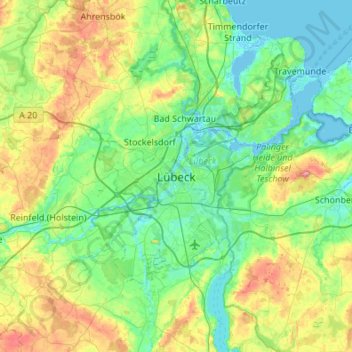
Name: Lübeck topographic map, elevation, terrain.
Location: Lübeck, Schleswig-Holstein, 23552, Allemagne (53.70644 10.52474 54.02644 10.84474)
Average elevation: 29 m
Minimum elevation: -4 m
Maximum elevation: 109 m
Other topographic maps
Click on a map to view its topography, its elevation and its terrain.
Quercus robur
Allemagne > Schleswig-Holstein > Lübeck
Quercus robur, Hofweg, Karlshof, Karlshof / Israelsdorf / Gothmund, Sankt Gertrud, Lübeck, Schleswig-Holstein, 23568, Allemagne
Average elevation: 8 m