
Make a donation
Lahore topographic map
Click on the map to display elevation.
Make a donation
About this map
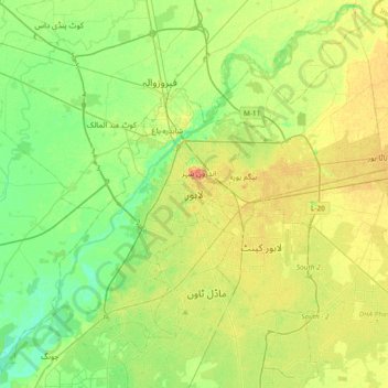
Name: Lahore topographic map, elevation, terrain.
Average elevation: 211 m
Minimum elevation: 196 m
Maximum elevation: 231 m
Make a donation
Other topographic maps
Click on a map to view its topography, its elevation and its terrain.
Faisalabad City Tehsil
The soil consists of young stratified silt loam or very fine sand loam which makes the subsoil weak in structure with common kankers at only five feet. The course of the rivers within Faisalabad is winding and often subject to frequent alternations. In the rainy season, the currents are very strong. This leads…
Average elevation: 185 m
Gujujranwala City Tehsil
Gujranwala sits at the heart of the Rechna Doab, a strip of land between the Chenab in the north, and Ravi River in the south. Gujranwala is also part of the Majha, a historical region of northern Punjab. The city was built upon the plains of Punjab, and the surrounding region is an unbroken plain devoid of…
Average elevation: 225 m