
Pienaars topographic map
Interactive map
Click on the map to display elevation.
About this map
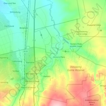
Name: Pienaars topographic map, elevation, terrain.
Average elevation: 1,095 m
Minimum elevation: 1,040 m
Maximum elevation: 1,202 m
Other topographic maps
Click on a map to view its topography, its elevation and its terrain.
Wonderboom Nature Reserve
Wonderboom Nature Reserve, Steve Biko Street, Tshwane Ward 54, Pretoria, City of Tshwane Metropolitan Municipality, Gauteng, 0116, RSA
Average elevation: 1,277 m
Tshwane Ward 80
Tshwane Ward 80, Pretoria, City of Tshwane Metropolitan Municipality, Gauteng, RSA
Average elevation: 1,357 m
Tshwane Ward 46
Tshwane Ward 46, Pretoria, City of Tshwane Metropolitan Municipality, Gauteng, RSA
Average elevation: 1,396 m
Tshwane Ward 3
Tshwane Ward 3, Pretoria, City of Tshwane Metropolitan Municipality, Gauteng, RSA
Average elevation: 1,399 m
Tshwane Ward 7
Tshwane Ward 7, Pretoria, City of Tshwane Metropolitan Municipality, Gauteng, RSA
Average elevation: 1,367 m
Tshwane Ward 92
Tshwane Ward 92, Pretoria, City of Tshwane Metropolitan Municipality, Gauteng, RSA
Average elevation: 1,351 m
Tshwane Ward 102
Tshwane Ward 102, Pretoria, City of Tshwane Metropolitan Municipality, Gauteng, RSA
Average elevation: 1,472 m
Magaliesberg Nature Area
Magaliesberg Nature Area, Birdflower Road, Tshwane Ward 7, Pretoria, City of Tshwane Metropolitan Municipality, Gauteng, RSA
Average elevation: 1,386 m
Tshwane Ward 56
Tshwane Ward 56, Pretoria, City of Tshwane Metropolitan Municipality, Gauteng, RSA
Average elevation: 1,380 m
Tshwane Ward 55
Tshwane Ward 55, Pretoria, City of Tshwane Metropolitan Municipality, Gauteng, RSA
Average elevation: 1,334 m
Tshwane Ward 44
Tshwane Ward 44, Pretoria, City of Tshwane Metropolitan Municipality, Gauteng, 0043, RSA
Average elevation: 1,406 m
Tshwane Ward 84
Tshwane Ward 84, Pretoria, City of Tshwane Metropolitan Municipality, Gauteng, RSA
Average elevation: 1,322 m