
Thank you for supporting this site ❤️
Make a donation
Make a donation
Ndindindi topographic map
Click on the map to display elevation.
Thank you for supporting this site ❤️
Make a donation
Make a donation
About this map
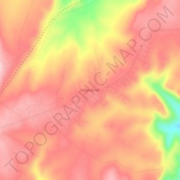
Name: Ndindindi topographic map, elevation, terrain.
Average elevation: 462 m
Minimum elevation: 298 m
Maximum elevation: 527 m
Thank you for supporting this site ❤️
Make a donation
Make a donation
Other topographic maps
Click on a map to view its topography, its elevation and its terrain.
Pondoland Inshore Restricted Zone
South Africa > Eastern Cape > O.R. Tambo District Municipality > Ingquza Hill Local Municipality
Average elevation: 44 m