
Lake Louise topographic map
Interactive map
Click on the map to display elevation.
About this map
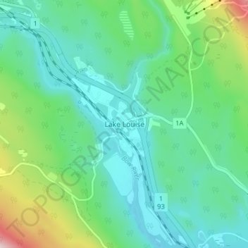
Name: Lake Louise topographic map, elevation, terrain.
Location: Lake Louise, Division No. 15, Alberta, Canada (51.40497 -116.19754 51.44497 -116.15754)
Average elevation: 1,617 m
Minimum elevation: 1,518 m
Maximum elevation: 1,934 m
Other topographic maps
Click on a map to view its topography, its elevation and its terrain.
Municipality of Jasper
Canada > Alberta > Division No. 15
Municipality of Jasper, Division No. 15, Alberta, T0E 1E0, Canada
Average elevation: 1,789 m