
Make a donation
Saint-Michel-de-Maurienne topographic map
Click on the map to display elevation.
Make a donation
Saint-Michel-de-Maurienne
Saint-Michel-de-Maurienne has a oceanic climate (Köppen climate classification Cfb). The station is located at an altitude of 700 m (2,300 ft); due to its location on a leeward slope, there is significantly less precipitation than nearby areas. It is quite common to exceed 30 °C (86 °F) in summer, sometimes the maximum temperature can reach 35 °C (95 °F), and in winter it is relatively rare to fall below −10 °C (14 °F). The average annual temperature in Saint-Michel-de-Maurienne is 11.0 °C (51.8 °F). The average annual rainfall is 754.3 mm (29.70 in) with December as the wettest month. The temperatures are highest on average in July, at around 20.3 °C (68.5 °F), and lowest in January, at around 1.3 °C (34.3 °F). The highest temperature ever recorded in Saint-Michel-de-Maurienne was 38.2 °C (100.8 °F) on 19 August 2012; the coldest temperature ever recorded was −16.6 °C (2.1 °F) on 5 February 2012.
Make a donation
About this map
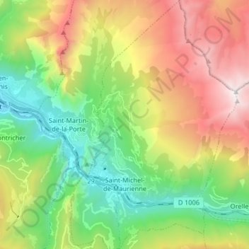
Name: Saint-Michel-de-Maurienne topographic map, elevation, terrain.
Average elevation: 1,590 m
Minimum elevation: 621 m
Maximum elevation: 3,107 m
Make a donation
Other topographic maps
Click on a map to view its topography, its elevation and its terrain.
Mollard Durand
France > Auvergne-Rhône-Alpes > Savoy > Saint-Martin-de-la-Porte
Average elevation: 1,050 m
Les Ménuires
France > Auvergne-Rhône-Alpes > Savoy
The resort was founded in 1964 and has an altitude range of 1,850 m (6,070 ft).
Average elevation: 2,063 m
Make a donation
Le Charvet
France > Auvergne-Rhône-Alpes > Savoy > Bourg-Saint-Maurice > Arc 1800
Average elevation: 1,651 m
Make a donation
La Ville des Glaciers
France > Auvergne-Rhône-Alpes > Savoy > Bourg-Saint-Maurice
Average elevation: 2,180 m
Le Grand Couloir
France > Auvergne-Rhône-Alpes > Savoy > Pralognan-la-Vanoise
Average elevation: 1,876 m
Make a donation
Le Désert d'Entremont
France > Auvergne-Rhône-Alpes > Savoy > Entremont-le-Vieux
Average elevation: 1,161 m
Make a donation
Make a donation
Make a donation
Make a donation
Le Laisonnay d'En Bas
France > Auvergne-Rhône-Alpes > Savoy > Champagny-en-Vanoise
Average elevation: 2,140 m
Make a donation