
Botterkloof Dam topographic map
Interactive map
Click on the map to display elevation.
About this map
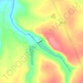
Name: Botterkloof Dam topographic map, elevation, terrain.
Average elevation: 1,760 m
Minimum elevation: 1,711 m
Maximum elevation: 1,799 m
Other topographic maps
Click on a map to view its topography, its elevation and its terrain.
Sand River
South Africa > Free State > Thabo Mofutsanyana District Municipality > Dihlabeng Local Municipality
Sand River, Dihlabeng Local Municipality, Thabo Mofutsanyana District Municipality, Free State, South Africa
Average elevation: 1,615 m
Bethlehem
South Africa > Free State > Thabo Mofutsanyana District Municipality > Dihlabeng Local Municipality
Bethlehem, Dihlabeng Local Municipality, Thabo Mofutsanyana District Municipality, Free State, 9700, South Africa
Average elevation: 1,675 m
Clarens
South Africa > Free State > Thabo Mofutsanyana District Municipality > Dihlabeng Local Municipality
Clarens, Dihlabeng Local Municipality, Thabo Mofutsanyana District Municipality, Free State, 9707, South Africa
Average elevation: 1,874 m
Fouriesburg
South Africa > Free State > Thabo Mofutsanyana District Municipality > Dihlabeng Local Municipality
Fouriesburg, Dihlabeng Local Municipality, Thabo Mofutsanyana District Municipality, Free State, South Africa
Average elevation: 1,745 m