
Thank you for supporting this site ❤️
Make a donation
Make a donation
East Beach topographic map
Click on the map to display elevation.
Thank you for supporting this site ❤️
Make a donation
Make a donation
About this map
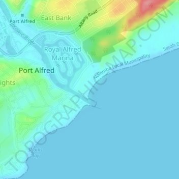
Name: East Beach topographic map, elevation, terrain.
Average elevation: 15 m
Minimum elevation: -3 m
Maximum elevation: 98 m
Thank you for supporting this site ❤️
Make a donation
Make a donation
Other topographic maps
Click on a map to view its topography, its elevation and its terrain.
Kowie River
South Africa > Eastern Cape > Sarah Baartman District Municipality > Ndlambe Local Municipality > Port Alfred
Average elevation: 57 m