
Thank you for supporting this site ❤️
Make a donation
Make a donation
Pleasant Ridge topographic map
Click on the map to display elevation.
Thank you for supporting this site ❤️
Make a donation
Make a donation
About this map
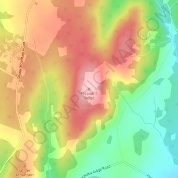
Name: Pleasant Ridge topographic map, elevation, terrain.
Average elevation: 157 m
Minimum elevation: 54 m
Maximum elevation: 252 m
Thank you for supporting this site ❤️
Make a donation
Make a donation
Other topographic maps
Click on a map to view its topography, its elevation and its terrain.
Grand Bay-Westfield
Canada > New Brunswick > Kings County > Town of Grand Bay-Westfield
Average elevation: 64 m
Thank you for supporting this site ❤️
Make a donation
Make a donation
Thank you for supporting this site ❤️
Make a donation
Make a donation