
Thank you for supporting this site ❤️
Make a donation
Make a donation
Villa Vásquez topographic map
Click on the map to display elevation.
Thank you for supporting this site ❤️
Make a donation
Make a donation
About this map
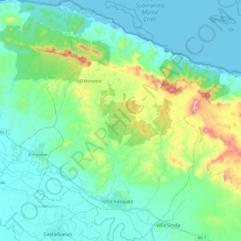
Name: Villa Vásquez topographic map, elevation, terrain.
Location: Villa Vásquez, Monte Cristi, 61706, República Dominicana (19.70729 -71.51774 19.90898 -71.35276)
Average elevation: 83 m
Minimum elevation: 0 m
Maximum elevation: 392 m
Thank you for supporting this site ❤️
Make a donation
Make a donation
Other topographic maps
Click on a map to view its topography, its elevation and its terrain.
Cristo Rey
República Dominicana > Monte Cristi > Monte Cristi > San Fernando de Monte Cristi
Average elevation: 14 m
Las Flores
República Dominicana > Monte Cristi > Villa Vásquez > Villa Vásquez > Las Flores
Average elevation: 37 m