
Make a donation
Mier Local Municipality topographic map
Click on the map to display elevation.
Make a donation
About this map
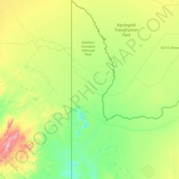
Name: Mier Local Municipality topographic map, elevation, terrain.
Average elevation: 982 m
Minimum elevation: 773 m
Maximum elevation: 2,067 m
Make a donation
Other topographic maps
Click on a map to view its topography, its elevation and its terrain.
Upington
South Africa > Northern Cape > ZF Mgcawu District Municipality
The elevation of Upington is 2,742 feet (835 metres). It is the closest large centre to the Augrabies Falls (arguably the greatest of South African waterfalls) and the Kgalagadi Transfrontier Park. The landscape is very arid but the soil is fertile and crops such as fruit are grown in irrigated fields. The…
Average elevation: 849 m
Kakamas
South Africa > Northern Cape > ZF Mgcawu District Municipality > Kai !Garib Local Municipality
Average elevation: 667 m
Postmasburg
South Africa > Northern Cape > ZF Mgcawu District Municipality > Tsantsabane Local Municipality
Average elevation: 1,327 m
Daniëlskuil
South Africa > Northern Cape > ZF Mgcawu District Municipality > Kgatelopele Local Municipality
Average elevation: 1,479 m
Make a donation
Kenhardt
South Africa > Northern Cape > ZF Mgcawu District Municipality > Kai !Garib Local Municipality
Average elevation: 808 m
Lime Acres
South Africa > Northern Cape > ZF Mgcawu District Municipality > Kgatelopele Local Municipality
Average elevation: 1,496 m
Groblershoop
South Africa > Northern Cape > ZF Mgcawu District Municipality > !Kheis Local Municipality
Average elevation: 884 m
Grootdrink
South Africa > Northern Cape > ZF Mgcawu District Municipality > !Kheis Local Municipality
Average elevation: 877 m
Make a donation
Augrabies
South Africa > Northern Cape > ZF Mgcawu District Municipality > Kai !Garib Local Municipality
Average elevation: 656 m
Upington
South Africa > Northern Cape > ZF Mgcawu District Municipality
The elevation of Upington is 2,742 feet (835 metres). It is the closest large centre to the Augrabies Falls (arguably the greatest of South African waterfalls) and the Kgalagadi Transfrontier Park. The landscape is very arid but the soil is fertile and crops such as fruit are grown in irrigated fields. The…
Average elevation: 849 m
Postmasburg
South Africa > Northern Cape > ZF Mgcawu District Municipality > Tsantsabane Local Municipality
Average elevation: 1,327 m
Make a donation
Groblershoop
South Africa > Northern Cape > ZF Mgcawu District Municipality > !Kheis Local Municipality
Average elevation: 884 m
Lohatlha
South Africa > Northern Cape > ZF Mgcawu District Municipality > Tsantsabane Local Municipality
Average elevation: 1,374 m
Upington
South Africa > Northern Cape > ZF Mgcawu District Municipality
The elevation of Upington is 2,742 feet (835 metres). It is the closest large centre to the Augrabies Falls (arguably the greatest of South African waterfalls) and the Kgalagadi Transfrontier Park. The landscape is very arid but the soil is fertile and crops such as fruit are grown in irrigated fields. The…
Average elevation: 849 m
Augrabies
South Africa > Northern Cape > ZF Mgcawu District Municipality > Kai !Garib Local Municipality
Average elevation: 656 m
Make a donation
Kakamas
South Africa > Northern Cape > ZF Mgcawu District Municipality > Kai !Garib Local Municipality
Average elevation: 667 m
Grootdrink
South Africa > Northern Cape > ZF Mgcawu District Municipality > !Kheis Local Municipality
Average elevation: 877 m
Kanoneiland
South Africa > Northern Cape > ZF Mgcawu District Municipality > Kai !Garib Local Municipality
Average elevation: 779 m
Groblershoop
South Africa > Northern Cape > ZF Mgcawu District Municipality > !Kheis Local Municipality
Average elevation: 884 m
Make a donation
Sout
South Africa > Northern Cape > ZF Mgcawu District Municipality > Kai !Garib Local Municipality
Average elevation: 850 m
Rietfontein
South Africa > Northern Cape > ZF Mgcawu District Municipality > Mier Local Municipality
Average elevation: 849 m
Klein Mier
South Africa > Northern Cape > ZF Mgcawu District Municipality > Mier Local Municipality
Average elevation: 843 m
Augrabies Falls
South Africa > Northern Cape > ZF Mgcawu District Municipality > Kai !Garib Local Municipality > Augrabies Falls Rest Camp
Average elevation: 618 m
Make a donation