
Zaprešić topographic map
Interactive map
Click on the map to display elevation.
About this map
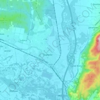
Name: Zaprešić topographic map, elevation, terrain.
Location: Zaprešić, Town of Zaprešić, Zagreb County, 10290, Croatia (45.82684 15.78090 45.89403 15.82952)
Average elevation: 153 m
Minimum elevation: 118 m
Maximum elevation: 451 m
Other topographic maps
Click on a map to view its topography, its elevation and its terrain.
Obed
Obed, Municipality of Orle, Zagreb County, Croatia
Average elevation: 101 m
Zaprešić
Croatia > Zagreb County > Zaprešić
Zaprešić, Town of Zaprešić, Zagreb County, 10290, Croatia
Average elevation: 162 m