
Moorreesburg topographic map
Interactive map
Click on the map to display elevation.
About this map
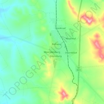
Name: Moorreesburg topographic map, elevation, terrain.
Average elevation: 172 m
Minimum elevation: 99 m
Maximum elevation: 347 m
Other topographic maps
Click on a map to view its topography, its elevation and its terrain.
Darling Wildflower Nature Reserve
South Africa > Western Cape > West Coast District Municipality > Swartland Local Municipality > Darling
Darling Wildflower Nature Reserve, R315, Nuwedorp, Swartland Ward 5, Darling, Swartland Local Municipality, West Coast District Municipality, Western Cape, South Africa
Average elevation: 148 m
Malmesbury
South Africa > Western Cape > West Coast District Municipality > Swartland Local Municipality
Malmesbury, Swartland Local Municipality, West Coast District Municipality, Western Cape, 7300, South Africa
Average elevation: 174 m
Koringberg
South Africa > Western Cape > West Coast District Municipality > Swartland Local Municipality
Koringberg, Swartland Local Municipality, West Coast District Municipality, Western Cape, South Africa
Average elevation: 151 m
Darling
South Africa > Western Cape > West Coast District Municipality > Swartland Local Municipality
Darling, Swartland Local Municipality, West Coast District Municipality, Western Cape, South Africa
Average elevation: 156 m
Riebeek-Wes
South Africa > Western Cape > West Coast District Municipality > Swartland Local Municipality
Riebeek-Wes, Swartland Local Municipality, West Coast District Municipality, Western Cape, 7307, South Africa
Average elevation: 262 m
Yzerfontein
South Africa > Western Cape > West Coast District Municipality > Swartland Local Municipality
Yzerfontein, Swartland Local Municipality, West Coast District Municipality, Western Cape, 7351, South Africa
Average elevation: 8 m
Riebeek-Kasteel
South Africa > Western Cape > West Coast District Municipality > Swartland Local Municipality
Riebeek-Kasteel, Swartland Local Municipality, West Coast District Municipality, Western Cape, 7307, South Africa
Average elevation: 186 m
Malmesbury
South Africa > Western Cape > West Coast District Municipality > Swartland Local Municipality
Malmesbury, Swartland Local Municipality, West Coast District Municipality, Western Cape, South Africa
Average elevation: 171 m