
Thank you for supporting this site ❤️
Make a donation
Make a donation
Oceanside topographic map
Click on the map to display elevation.
Thank you for supporting this site ❤️
Make a donation
Make a donation
About this map
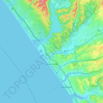
Name: Oceanside topographic map, elevation, terrain.
Location: Oceanside, San Diego County, California, United States (33.13257 -117.43980 33.30007 -117.23658)
Average elevation: 33 m
Minimum elevation: -7 m
Maximum elevation: 240 m
Thank you for supporting this site ❤️
Make a donation
Make a donation
Other topographic maps
Click on a map to view its topography, its elevation and its terrain.