
Thank you for supporting this site ❤️
Make a donation
Make a donation
Mount Washington topographic map
Click on the map to display elevation.
Thank you for supporting this site ❤️
Make a donation
Make a donation
About this map
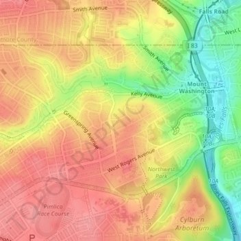
Name: Mount Washington topographic map, elevation, terrain.
Location: Mount Washington, Baltimore, Maryland, United States (39.35501 -76.68166 39.37196 -76.64999)
Average elevation: 109 m
Minimum elevation: 53 m
Maximum elevation: 144 m
Thank you for supporting this site ❤️
Make a donation
Make a donation
Other topographic maps
Click on a map to view its topography, its elevation and its terrain.