
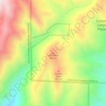
Little Bear topographic map
Interactive map
Click on the map to display elevation.
About this map
Name: Little Bear topographic map, elevation, terrain.
Average elevation: 807 m
Minimum elevation: 441 m
Maximum elevation: 1,189 m
Other topographic maps
Click on a map to view its topography, its elevation and its terrain.
Chain Lakes
United States > Washington > Chelan County
Chain Lakes, Chelan County, Washington, United States
Average elevation: 1,697 m
Leavenworth
United States > Washington > Chelan County
Leavenworth, Chelan County, Washington, United States
Average elevation: 418 m
Cashmere
United States > Washington > Chelan County
Cashmere, Chelan County, Washington, United States
Average elevation: 298 m
Dagger Lake
United States > Washington > Chelan County
Dagger Lake, Chelan County, Washington, United States
Average elevation: 1,845 m
Jay Peak
United States > Washington > Chelan County
Jay Peak, Chelan County, Washington, United States
Average elevation: 1,829 m
Lake Louis
United States > Washington > Chelan County
Lake Louis, Chelan County, Washington, United States
Average elevation: 1,325 m
Wenatchee
United States > Washington > Chelan County
Wenatchee, Chelan County, Washington, 98801, United States
Average elevation: 302 m