
Cape Point topographic map
Click on the map to display elevation.
Cape Point
The new lighthouse is at a lower elevation (87 meters; 285.5 feet above sea level), for two reasons: the old lighthouse, located at 34°21′12″S 18°29′25.2″E / 34.35333°S 18.490333°E / -34.35333; 18.490333 (262 meters; 859.6 feet above sea level), could be seen 'too early' by ships rounding the point towards the east, causing them to approach too closely. Secondly, foggy conditions often prevail at the higher levels, making the older lighthouse invisible to shipping. On 18 April 1911, the Portuguese liner Lusitania was wrecked just south of Cape Point at 34°23′22″S 18°29′23″E / 34.38944°S 18.48972°E / -34.38944; 18.48972 on Bellows Rock for precisely this reason, prompting the relocation of the lighthouse.
About this map
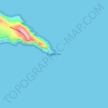
Name: Cape Point topographic map, elevation, terrain.
Average elevation: 8 m
Minimum elevation: 0 m
Maximum elevation: 205 m
Other topographic maps
Click on a map to view its topography, its elevation and its terrain.
Zandvlei Estuary Nature Reserve
South Africa > Western Cape > City of Cape Town
Average elevation: 41 m
Witzands Aquifer Nature Reserve
South Africa > Western Cape > City of Cape Town > Atlantis
Average elevation: 83 m
Cape Town Ward 98
South Africa > Western Cape > City of Cape Town > Khayelitsha
Average elevation: 27 m
Cape Town Ward 69
South Africa > Western Cape > City of Cape Town > Noordhoek
Average elevation: 137 m
Cape Town Ward 11
South Africa > Western Cape > City of Cape Town > Kuilsrivier
Average elevation: 58 m
Blaauwberg Nature Reserve
South Africa > Western Cape > City of Cape Town > Melkbosstrand
Average elevation: 46 m
Llandudno Beach
South Africa > Western Cape > City of Cape Town > Cape Town > Llandudno
Average elevation: 108 m
Cape Town Ward 111
South Africa > Western Cape > City of Cape Town > Kraaifontein
Average elevation: 109 m
Cape Town Ward 21
South Africa > Western Cape > City of Cape Town > Bellville
Average elevation: 132 m
Dianthus Street Park
South Africa > Western Cape > City of Cape Town > Somerset West
Average elevation: 89 m